Человек за всю свою историю не натворил того что натворил за последние 100 лет, вот напремер изменнённые ландшафты человеком с высоты. В обыденной жизни мы и не замечаем что земные контуры изменились с помощью человека. Если посмотреть хотябы с высоты птичего полёта а гдето и повыше надо забраться, то мы увидем что наш земной шар обритает рисунки, словно тату на человеке. Эти изменённые ландшафты человеком, в некоторых случаях не несут за собой не каких последствий, а в большенстве случаев, наши правнуки вспомнят нас хорошим словом в ковычках. Нет это конечно хорошо когда посёлок находится в доль воды, особенно если все дома стоят на берегу, искуственно построенном человеком. Но если вдуматься что сколько вредных отходов жизнидеятельности человека поподает в воду, одна только венеция скидывет всю канализацию в море тысячами тон. Природа не железная, рано или поздно ей надоест, и она напомнит о себе, и о тех рукотворных рисунках на земле.....

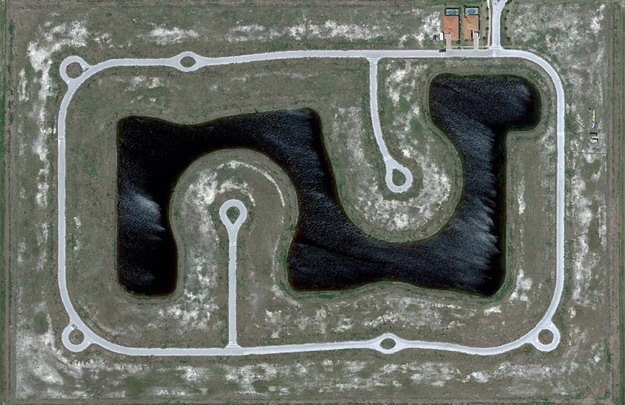
A section of a partially built residential project with only two houses in place, near Fort Myers, Florida. Map. (© Google)
A strip of houses in a neighborhood southeast of Fort Myers, Florida. Map, Street View. (© Google) #
Circular layouts of homes near I-75, southwest of Fort Myers, Florida. Map. (© Google) #
Once proposed as the 57,000 acre "Golden Gate Estates", this area was to be the largest subdivision in America in the 1960s. Many canals and roads were built, but the development eventually went bankrupt. Over the past 20 years or so, the land has been acquired by the state, and converted into the Picayune Strand State Forest. Map, Street View. (© Google/USGS)
Boats make their way through canal structures in a neighborhood north of Cape Coral, Florida. Map, Street View. (© Google)
The Rotonda West neighborhood, originally developed in the 1960s, never quite fully completed, located in Charlotte County, Florida. Map, Street View. (© Google/Data SIO, NOAA, U.S. Navy, NGA, GEBCO)
A densely built gated community in Bonita Springs, Florida. Map, Street View. (© Google)
A community built around a man-made lake southeast of Bonita Springs, Florida. Map. (© Google)
Empty cul-de-sacs fill an area south of Rotonda West in Charlotte County, Florida. Map, Street View. (© Google)
A developed neighborhood and one under construction in Lehigh Acres, Florida. Map. (© Google)
A densely populated neighborhood of Cape Coral, Florida. Map, Street View. (© Google)
A development built near North Fort Myers Florida on the Caloosahatchee River. Map, Street View. (© Google/Europa Technologies)
A partly developed, now partly overgrown neighborhood north of Lehigh Acres, Florida. Map, Street View. (© Google)
The Dade-Collier Training and Transition Airport was originally planned as the Everglades Jetport, and construction started in 1968 on what was to be the world's largest airport with six runways to support supersonic transport. Being surrounded by the Big Cypress National Preserve, environmental concerns halted construction, and when commercial supersonic transport didn't arrive, the project was left as-is, now a lightly-used airport. Map, Street View. (© Google/USGS/DigitalGlobe)
A grid of undeveloped avenues west of Port Charlotte, Florida. Map, Street View. (© Google)
A neighborhood in Port Charlotte, Florida. Map. (© Google)
A partially-developed community near Charlotte harbor, north of Fort Myers, Florida. Map, Street View. (© Google)
Homes line a man-made lake shore near Naples, Florida. Map. (© Google) #
Canals and homes in Charlotte Park, south of Port Charlotte, Florida. Map, Street View. (© Google/Europa Technologies)
A tightly developed parcel of land north of Englewood, Florida. Map, Street View. (© Google)
Part of Verona Walk, a gated community in Naples, Florida. Map. (© Google)
Homes laid out closely in circular arrangements north of North Fort Myers, Florida. Map. (© Google)
A series of residential developments in varying states of completion along a highway south of Naples, Florida. Map. (© Google/USGS)
Naples Park, a densely developed community north of Naples, Florida. Map. (© Google)
Canals and homes near Big Marco River on Marco Island, Florida. Map, Street View. (© Google/USGS)
Construction equipment sits parked among empty cul-de-sacs and a man-made lake in a development southeast of Fort Myers, Florida. Map. (© Google)
*** Прикрепления: | 
